The concept of DTaC (Digital Twins as Convergence) is fundamental for supporting the entire life cycle of a city, encompassing planning, construction, management, and operations. This approach integrates information-rich 3D models of the city through the convergence of BIM (Building Information Modeling), GIS (Geographic Information Systems) adnd real-time data from IoT.
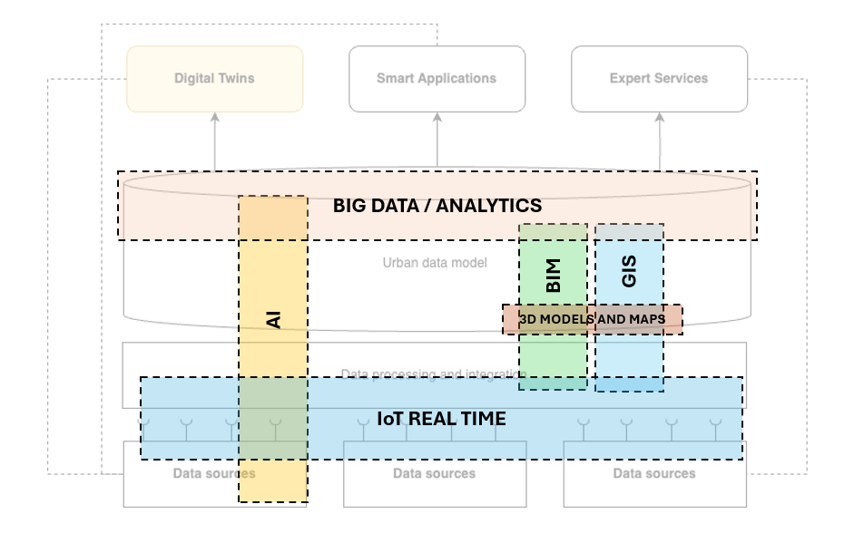
Table of contents
Open Table of contents
Information-rich 3D models
In the context of smart cities, digital twins rely heavily on detailed 3D models that integrate Building Information Modeling (BIM) and Geographic Information Systems (GIS). These 3D models offer a comprehensive representation of the built environment, encompassing architectural details, spatial relationships, and geospatial data. However, the value of these models extends beyond mere structural information. They incorporate vast amounts of data from various systems outside the traditional BIM workflow, such as infrastructure networks, environmental monitoring systems, and even socio-economic datasets. This holistic approach ensures that city planners and managers have access to a multi-dimensional view of the urban environment, enabling more informed decision-making and efficient management of city resources.
Integration of IoT for real-time urban data
The integration of Internet of Things (IoT) technology is pivotal for maintaining a near-real-time overview of urban operations. IoT sensors are strategically deployed across the city to gather data on a multitude of parameters including traffic flow, air quality, energy consumption, waste management, and public safety. These sensors act as the nervous system of the smart city, continuously feeding data into the digital twin. This constant stream of information allows city officials to monitor conditions in real-time, respond promptly to issues, and make proactive adjustments to urban systems. For instance, traffic management systems can dynamically adjust signals based on real-time traffic data, reducing congestion and improving the efficiency of transportation networks.
Handling large data volumes with Big Data and AI
The high volume and complexity of data generated by a smart city necessitate robust Big Data technologies and sophisticated artificial intelligence (AI) algorithms. These technologies are crucial for aggregating, processing, and analyzing historical and real-time data. Big Data platforms enable the storage and retrieval of massive datasets, while AI and machine learning models can identify patterns, predict future trends, and provide actionable insights. This analytical capability is indispensable for optimizing urban planning and operations. For example, predictive analytics can forecast energy demand, allowing for more efficient distribution and consumption. Similarly, AI-driven insights can enhance emergency response by predicting the likelihood of incidents in specific areas based on historical data.
Use cases and simulations
Digital twin concept are applied to a range of specific use cases that deliver tangible business benefits and address the diverse interests of various stakeholders. These use cases often involve simulations that model the performance of urban infrastructures and services under different scenarios. Simulations can test the impact of new policies, infrastructure developments, or emergency situations, providing a safe environment to explore potential outcomes and refine strategies. IoT sensors are leveraged to collect detailed performance data, which is then used to validate and refine simulation models. For instance, a digital twin might simulate the effects of a new public transportation route, considering factors such as passenger flow, energy usage, and traffic impact, to ensure that the proposed solution meets the city’s needs effectively.
Data integration and challenges
Data collected from various sources, such as IoT, BIM, and GIS, will be shared under the concept of City Data Mesh to overcome data integration challenges. In a City Data Mesh approach, data is not stored in individual silos but organized as interoperable data products accessible through a distributed infrastructure. This allows data from IoT sensors, BIM models, and GIS systems to be seamlessly integrated and shared across a network of data products, eliminating the need for a tremendous amount of manual work to connect these data sources. Conventional business intelligence tools and artificial intelligence can then be applied to these data products to provide valuable insights and learning, thereby improving decision-making and operational efficiency in the urban environment.
Digital Twin convergence levels
The convergence of GIS, BIM, 3D models, and real-time IoT data provides a powerful tool for comprehensive information management, significantly enhancing the capability for planning, execution, and monitoring in various urban and infrastructure contexts. The convergence of different information sources, such as GIS (Geographic Information Systems), BIM (Building Information Modeling), 3D models, and real-time IoT (Internet of Things) data, is leveraged in the context of data integration, hierarchical fusion, and comprehensive space management. Below is a description of each key component and how they integrate to provide advanced information management and visualization solutions.
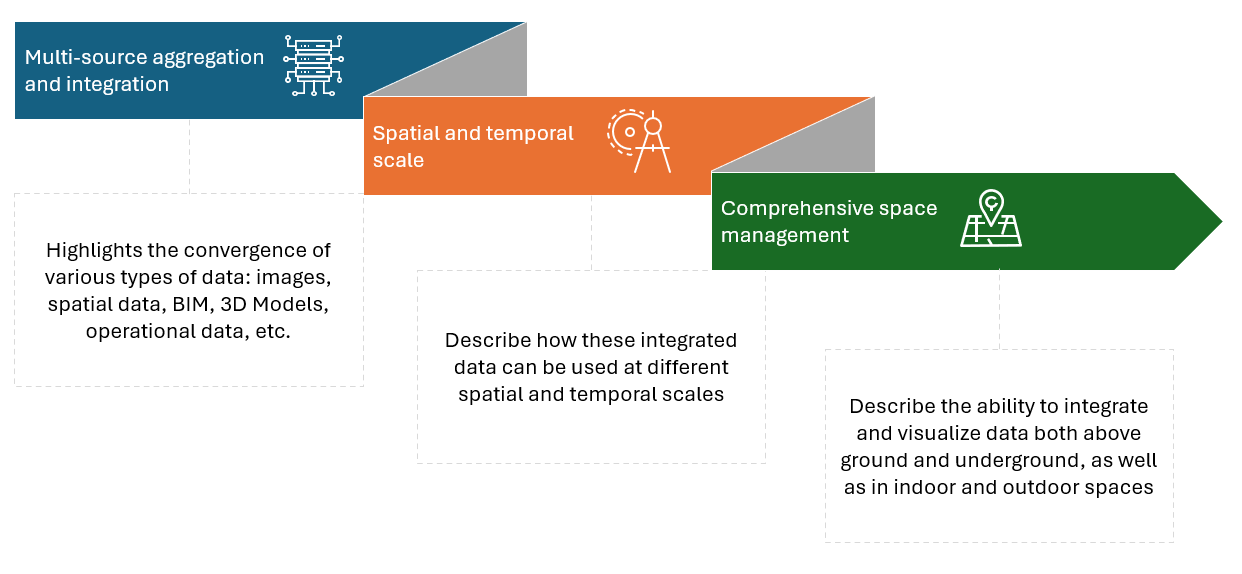
- Multi-source aggregation and integration
Highlights the convergence of various types of data, including:
- Image: visual data obtained from aerial photographs, satellites, and drones, providing a realistic view of terrain and structures.
- Vector: graphic representations of spatial data, such as parcel boundaries, roads, and utility networks, essential for GIS analysis.
- Mesh: three-dimensional models that represent complex surfaces and topographic details.
- Simple model: basic 3D structures providing an initial representation of buildings and land.
- BIM (Building Information Modeling): detailed models including information about the construction, maintenance, and operation of buildings.
- City design model: detailed representations of urban planning and city design, enabling visualization and planning of urban development.
- Detailed Model: High-detail 3D models allowing in-depth analysis of structures.
- Perception data: information obtained from real-time IoT sensors, such as traffic data, air quality, and environmental conditions.
- Operational data: information generated by expert services, capturing the operational aspects of city services and infrastructure.
Example: a comprehensive urban digital twin integrates all these data sources to create a dynamic, real-time model of a city. This snart application collects drone imagery for updated maps, uses GIS data for infrastructure planning, employs 3D meshes for topographical details, and incorporates BIM for detailed building information. City planners use simple models for visualizing new developments and detailed city design models to plan urban growth. Real-time perception data from IoT sensors monitor traffic and environmental conditions, while operational data from expert services help manage city services efficiently. This integrated approach supports informed decision-making, efficient resource management, and sustainable urban development.
- Spatial and temporal scale
Describe how these integrated data can be used at different spatial and temporal scales:
- Space scale: enables visualization and analysis of data at various levels of detail, from a macro view of the entire city to a micro view of an individual building. Example: a city management system that provides different views ranging from a city-wide perspective to detailed street-level insights for maintenance and planning.
- Time scale: facilitates tracking and managing changes over time, allowing for more effective planning and response to future events and developments. Example: an infrastructure monitoring platform that uses historical and real-time data to predict and manage the lifecycle of city assets such as bridges and roads.
- Comprehensive space management
Describe the ability to integrate and visualize data both above ground and underground, as well as in indoor and outdoor spaces:
- Over ground and underground: allows complete infrastructure management, from underground pipes and cables to surface buildings and roads. Example: an integrated utility management system that maps and manages both underground infrastructure like sewage systems and above-ground facilities like electrical grids.
- Indoor and Outdoor details: offers a holistic view that includes both the interior of smart urban spaces and their external details environment, facilitating comprehensive property and urban management. Example: a smart city initiative that integrates data from indoor spaces like public buildings with outdoor public spaces to optimize energy use and enhance urban living conditions.